
Monday, September 30, 2013


Recovering the plane
Sunday 22 sept looked like the day to bring the plane home, so drove the rental car back the day before. This pic taken somewhere over upper east TN.
Low clouds
The next morning we set off for home but did not get too far due to low clouds and high terrain. We returned to the airport and from the forecast it looked like this could hang around a few days. I decided to rent a car and return after the next front came thru to clear things out. Rental car and a short term hangar space were available and we were on our way soon.
Murfreesboro TN
Clouds built steadily during the rest of the day but no problem making our planned stop for the night here. This was also a very nice airport for a stop by a transient.
Departing OK
On the morning of 17 sept amid scattered showers in the area. Weather improved as we headed east. Our first stop for the day was at a nice airport in Russelville AR. The car you see in the pic is the courtesy car they let us use to go for lunch whic was very close by. A very nice stop.
Monday, September 16, 2013

Childress TX Airport
Turning left base for runway 18. Did not need gas but my bladder wasn't going to make it to OKC. No one found here and no wifi signal heard to update weather this Sunday morning. We were off again quickly, this time for the Wiley Post airport north of Oklahoma City


Early Start
Off the Carlsbad airport toward Oklahoma City where Junes brother and sister live. Here we are swinging to the northeast at dawn after departing runway 26 at Carlsbad.

Caverns
We were unfortunately too late in the day to go in the caverns but we saw the "bat flight" at sunset which was quite a sight. But this night they were late and there was not much light to see them well. No photos of the flight were allowed.


Pinalino Mts
Some dreaded mountain obscuration found near Safford AZ. Perhaps related to the rain the day before

Scottsdale Airport
Scottsdale Air Center was a wonderful facility with great service, but I felt a bit out of place among the corporate jets--I did not see any other prop planes while I was there. This airport was closest to my cousin Michael, who graciously took us in for a couple days while we waited for more of the monsoon to clear from the desert.
Off Toward Phoenix
The Colorado River at Blythe CA. Not many good landing options between here and the PHX area.


Apple Valley airport
Stopped here for what turned out to be a few days due to weather in AZ. We drove to Big Bear one day and Santa Monica and Hollywood area the second day
Rogers lake
Off Merced on the morning of 9 sept. after crossing the tehachapi mountains, this view of Edwards AFB in the background and the rosamond dry lake bed under the left wing. Traces of smoke from the yosemite rim fire were with us until Bakersfield. We heard us called as traffic to a Uav spotter plane thru this area.
Wednesday, September 11, 2013
Nevada falls
...after ascending many more steps along the mist trail. We originally though we could continue on to the top of half dome and I had even secured the required permit. But I don't know what we were thinking. This falls isn't even half way --and we were beat. That's June 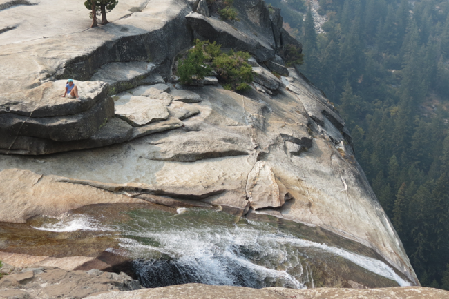 resting on the lleft
resting on the lleft

But looking northwest...
Some smoke evident. Wind had been pretty much out of the south, making things not to bad in yosemite valley. But I think the wind shifted...


Control Lock system
Arrangement of bungee cords and rod to hold the rudder pedals against the wing spar seemed to be working of so far. 

Over the Eastern OR wilderness
At 10500' below radar coverage but thankfully good FSS radio coverage for position reporting
Eastern OR
Over some relatively remote areas of eastern OR. We wanted to go to the Portland area but had to divert due to weather. So we break off the trial near Caldwell ID and make for klammath falls. This pic is looking to the northeast as we approach Burns OR
Three islands crossing
This is near Glenn's ferry and these three islands were used by some pioneers to cross the snake. This is looking east upriver


Arch bridge
A view of the bridge from the south end looking north. This is a big "base jumping" spot. It was a bit windy but this one brave guy jumped. You can see his chute near the north shore of the river. They had a target zone marked on the south bank. He fell a bit short and seemed to go into some bushes but seemed ok. I could not imagine them allowing this sort of random jumping anywhere back east. 
Up the snake river
View looking up the snake river from under the arch bridge. Note the water fall to the left. There were lots of these spring fed falls tumbling into the snake.
Shoshone Falls
A beautiful park in Twin Falls called Shoshone park. We were told the snake river was unusually low amid the the falls are usually more dramatic

Snake River Valley
Entering the valley near pocatello and following  the Oregon trail with the official park service map.
the Oregon trail with the official park service map.
Soda springs ID
Approaching the town of soda springs. I had heard that some wagon ruts were actually visible in the towns golf course. We did not land here though. We are following the roads mostly looking for Pocatello where we will enter the snake river valley and turn toward twin falls
Bear Lake
Off the next morning for twin falls I'd from rock springs. Bear lake is visible in the distance. I think it's actually in Utah but I think we are over wy or ID here. 

Near South Pass
The Sweetwater headwaters near South Pass. This is where the trail crossed the continental divide. Elevation here about 8000'. You can see the shadow of a contrail to the right of the river
Subscribe to:
Posts (Atom)